


Trimble GPS Maps Free (formerly Cabela's Recon Maps)
+ View full-color topo maps and aerial images
+ Drop waypoints
+ Check local weather reports
+ Scout potential hunting lands and fishing spots
+ Send preplanned trips to other Trimble GPS apps (GPS Hunt & GPS Fish)
Trimble GPS Maps Free (formerly Cabelas Recon Maps)is the best way to plan and organize your next hunting trip or fishing trip. Use this app to research hunting lands, find fishing spots, and scout access roads.
------------------
------------------
NEW: Check out our new SD/microSD memory cards with topo maps and private land ownership details, including plot boundaries, land owners name, parcel number and address. Just drag maps from the SD card into iTunes. Then sync iPad. More at: www.gpshuntfish.com/sdcards
------------------
------------------
** OUTDOOR MAPS **
Research place before you go out there by checking out our beautiful, full-color raster maps.
•View five different map types: streets, hybrid, aerial, topo, and terrain.
•Access more than 68,000 topographic maps in U.S. and Canada. Topos scales are 1:24K in the Lower 48, 1:63K in Alaska and 1:50K in Canada.
•See two maps at once. No single map type has all the essential details to plan your next outing. So turn on Dual Map View and fade between two different map types at once.
** TRIP TOOLS **
The GPS Maps app features a quiver of tools to help you find that trophy buck or catch the big one.
Waypoints: Drop-and-drag waypoints on to the map. Name them and add descriptions, whether it’s a boat dock, fishing hotspot, or deer camp.
Place Search: Looking for new lakes brimming with bass, or that hidden meadow full of elk? Use our search to find more than 10 million places. Find trails, peaks, lakes, rivers, forests, and more.
Digital Compass: Press the mini-compass to overlay a large digital compass on the map. See compass bearing and declination too.
Ruler: Need to find out the distance from deer camp to hunting stand? It’s easy to measure the distance between any two points.
Smart Paste: Copy GPS coordinates from hunting and fishing websites and instantly map their locations into GPS Maps.
Coordinates: Match your latitude/longitude or UTM coordinates to your paper map, GPS device, or Recon app. Supported map datum: WGS84 and NAD27.
Any Device: See trips planned in GPS Maps on your smartphone and personal computer at GPSHuntFish.com. Trips are saved to your account and can be viewed on these other devices.
**ELITE MEMBERSHIP**
Get access to exclusive features and outdoors maps on your phone, tablet, and PC. As an Elite member, you get:
Lake Maps
View underwater charts for over 6,900 lakes in the U.S. See depth contours down to 10-foot intervals. Coverage includes popular bass, walleye, northern pike, and trout fisheries.
Weather Maps
View real-time Weather Maps (Doppler, wind, cloud cover, air temperature, ocean temperature).
Public Lands
View public land boundaries to find access points to hunting lands, lakes, and rivers.
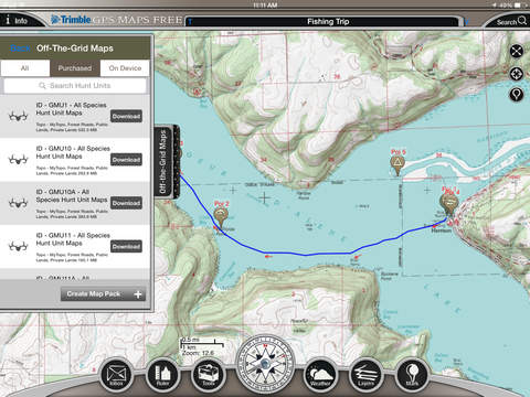
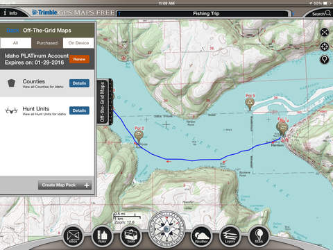
Mega Offline Map
Access more than 3,000 bundles. Download topographic maps on your phone by state, county, and hunt unit.
More Apps
Get full-access to all the features in all our hunting and fishing apps: Trimble GPS Maps, Trimble GPS Hunt, and Trimble GPS Fish.
Forest Roads
See whether dirt roads are open or closed in 134 national forest and BLM lands.
Trip Planner
Plan trips online with our Trip Planner on our website. Mark waypoints, draw tracks, import GPS and GPX files from other map programs and GPS devices.
Print Maps
Print high-quality maps on your home printer. Plus, Elite members get 20% off all custom printed map orders at MyTopo.com.
-------
NOTES: Trimble GPS Maps is designed and optimized for iPads. It works on both the Wifi and 3G models but the Wifi models lack a GPS chip required to show your exact location. Continued use of GPS running in the background can dramatically decrease battery life.